The largest river in the European territory of our country. The largest river in Europe
HOLIDAY ON THE RIVERS
Volga - the most big river Europe is 3888 km long with a basin area of 1360 thousand km 2. It originates on the Valdai Hills, flows into the Caspian Sea, forming a delta with an area of 19 thousand km 2. It has about 200 tributaries, the largest being the Kama and Oka. The flow is highly regulated by a cascade of hydroelectric power stations and reservoirs. The largest hydroelectric power stations are Volzhskaya (Kuibyshevskaya), Volzhskaya (Volgogradskaya), Cheboksary. The Volga is connected to the Baltic Sea by the Volga-Baltic Waterway, to the White Sea by the North Dvina Water System and the White Sea-Baltic Canal, to the Azov and Black Seas by the Volga-Don Shipping Canal, and to the Moskva River by the Moscow Canal. In the Volga basin there are the Volzhsko-Kama, Zhigulevsky and Astrakhansky nature reserves national park Samara Luka.
Kama - the fifth longest river in Europe (2030 km): only the Volga, Danube, Ural and Dnieper are longer than it, the Kama is one of the most important river highways, has more than 200 large tributaries, such as the Vishera, Chusovaya, Belaya, Vyatka, etc. Drain The Kama River is regulated for a considerable length by the dams of the Kama, Botkinsk and Nizhnekamsk hydroelectric power stations, above which reservoirs were created. At the confluence of the Kama and the Volga there is the Volzh-1-Kama Nature Reserve.
Nature of the Kama Basin is diverse and includes the slopes of the Ural ridge, ancient plateaus, and lowland plains. In the upper reaches - coniferous forests, in the lower reaches there are oak groves and lindens.
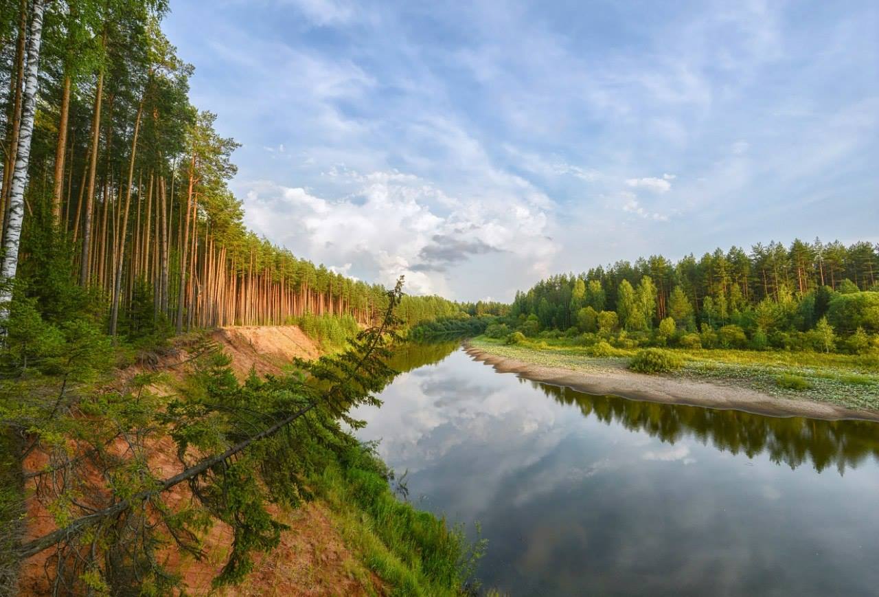
Oka - the second largest tributary of the Volga, has a length of 1478 km. It originates on the Central Russian Upland, 4 km from the village. Maloarkhangelsk. Flows into the Volga Nizhny Novgorod. According to hydrological data and the nature of the path, it is divided into upper, middle and lower sections. Verkhnyaya Oka - from the city of Aleksin to the village. Shchurovo. Average - from the village. Shchurovo (mouth of the Moscow River) to the mouth of the river. Moksha. Here it differs sharply from the upper section - the slopes decrease, the river becomes more abundant. For 100 km (river Shchurovo - Kuzminsk) there is a lock section. The Lower Oka (from the mouth of the Moksha River to Nizhny Novgorod) is characterized by frequent narrowing and widening of the channel from 1 to 2 km. The right bank (from Pavlov to Gorky) is high, the left bank (from Murom to Nizhny Novgorod) is low. Along the banks of the Oka there are cliffs on one side, and water meadows on the other. Closer to the confluence with the Volga, the Oka becomes fuller, coniferous forests and copses appear on the banks.
The main tributaries of the Oka: Ugra, Moscow River, Klyazma, Moksha. On the left bank in the middle reaches is the Prioksko-Terrasny Nature Reserve. The Oka is navigable from the city of Chekalin, regular shipping is from Serpukhov.
Don begins on the Central Russian Upland. The length of the Don is about 1970 km, the basin area exceeds 440 thousand km 2. It flows into the Taganrog Bay of the Sea of Azov, forming a delta with an area of 340 km 2. Small slopes in the lower reaches provide a very slow flow. The main tributaries: Khoper, Medveditsa, Sal, Seversky Donets. The Tsimlyanskaya hydroelectric power station and reservoir, Nikolaevsky, Konstantinovsky and Kochetkovsky hydroelectric complexes are located on the Don. Navigation from the mouth of the river. Sosny (1604 km), regular shipping - from the town of Liski. In the Don basin - a nature reserve Galichya Mountain. The largest cities: Liski, Kalach-on-Don, Rostov-on-Don, Azov, Volgodonsk.
Half of European cities were built on rivers, which is not surprising, because rivers have always had important transport and economic importance for urban development. After all, people just love to relax on the banks of rivers, enjoying the scenery and clean water, and many - and fishing in it. The size of the rivers on which cities stand can vary greatly, and this does not mean that the largest cities should be on the largest rivers. About which one is the most long river in Europe, and will be discussed below.
1. Volga (3531 km)
It is the great Russian river that is the longest water artery in Europe. It must be admitted that in terms of length, the European record holder is far behind the longest rivers in the world, such as the Amazon, Nile, Yangtze, but in a fairly compact Europe this is already a good result. The Volga, like many other Eastern European rivers (Dnieper, Western Dvina, etc.) begins on the Valdai Upland, then flows along the Central Russian Upland to the southeast, at the foothills of the Urals it turns south and flows into the internal Caspian Sea. The source of the Volga is located at an altitude of 228 meters above sea level, but its delta goes 28 meters below this level. Usually the Volga flow is divided into three sections: the upper, middle and lower Volga. In its basin, which occupies 8% of the territory of Russia, there are over 150 thousand large and small rivers.
In that part of the world that is called America there are many waterfalls not only in its southern continent, but also North America can also be proud of something. Residents of the USA...
2. Danube (2860 km)
.jpg)
This is the longest river Western Europe. It begins in Germany, and then flows through the territories of 10 countries until it flows into the Black Sea. Over such a long journey, the landscapes of the Danube banks change greatly: high mountains, glaciers, mountain plateaus, karst plateaus, forested plains and fields. The Danube water has a yellowish-brown tint due to the abundance of suspended particles of silt carried away from the banks, so the “blue” Danube, praised by Johann Strauss, is also considered the muddiest European river. For Western Europe, the Danube is not only the longest, but also the deepest river.
3. Ural (2428 km)
.jpg)
The sources of the Ural River are located in Bashkiria, at the top of the Kruglaya Sopka mountain. Almost its entire path, the Urals flows through the territory of Russia, capturing a small piece of Kazakhstan, after which, like the Volga, it flows into the Caspian Sea. Along the upper part of the channel of the Urals runs the conventional border of dividing the Eurasian continent into 2 continents - Europe and Asia. The cities of Orenburg and Magnitogorsk were built on the Ural River. From a shipping point of view, the Urals do not have much of great importance- There are few river boats here. But there is active fishing here, since there is a lot of it in the Urals - catfish, stellate sturgeon, pike perch, sturgeon. The Ural basin covers an area of 231,000 square meters. km.
4. Dnieper (2201 km)
.jpg)
The Dnieper River flows through the territories of Russia, Belarus and then Ukraine, and for the latter it is the longest river. The Dnieper begins very close to the Volga - on the Valdai Hills, but at the end of the road it flows into the Black Sea. On the banks of the Dnieper there are such large cities as Kyiv and Dnepropetrovsk. The Dnieper, like a typically flat river, has a calm, slow flow, and everyone has long forgotten about the Dnieper rapids, which became the bottom of reservoirs. The Dnieper is home to over 70 species of fish, including sturgeon, carp, ram and herring. Also, many types of algae grow in the Dnieper water: the most common are green, but there are also golden, diatoms, and cryptophytes.
5. Don (1870 km)
.jpg)
The sources of the Don are located on the Central Russian Upland, and it flows into the Sea of Azov. There is a misconception that the source of the Don is located in the Shatsky reservoir, but in fact its beginning is the Urvanka stream, which flows in Novomoskovsk, Tula region (tap water flows at the site of the formal source). The Don is a navigable river, and its basin covers 422,000 square meters. km. River boats rise from the mouth of the Don to the city of Liski. Many cities were built on this ancient Russian river, including such large ones as Voronezh, Rostov-on-Don, Azov. Unfortunately, the Don was heavily polluted, which led to a reduction in its fish stocks. But even now it is home to almost 70 species of fish. The most common fish caught here are roach, bream, rudd, pike and perch.
6. Pechora (1809 km)
.jpg)
This northern river flows through the territory of Komi and Nenets Autonomous Okrug, and then flows into the Barents Sea. The sources of Pechora are located in the Northern Urals. Naryan-Mar stands on its banks. Pechora is navigable, but only to Troitsko-Pechorsk. Whitefish, salmon and vendace are actively caught here. The Pechora basin, occupying 322,000 square meters. km, rich in mineral deposits: coal, gas and oil.
On our planet, only 14 mountain peaks have a height of more than 8000 meters. Most of the peaks are located in the Himalayas and are known to everyone under the name "...
7. Kama (1805 km)
.jpg)
This is the longest river in Europe, which is a tributary and the largest river of the Western Urals. The sources of the Kama are located on the Verkhnekamsk Upland, near the village of Karpushata. In the area of the Kuibyshev reservoir, the Kama flows into the Volga - the longest European river. The area of the Kama basin is 507,000 square meters. km, where there are almost 75 thousand rivers and streams. True, the vast majority of them are only about ten kilometers long. It is interesting that the Kama is much older than the Volga; before the last glaciation, it itself flowed into the Caspian Sea, while the Volga merged with the Don. After the passage of the glacier, which greatly changed the terrain, much changed - the Kama became the largest tributary of the Volga.
8. Oka (1498 km)
.jpg)
The largest right tributary of the Volga is the Oka River, which has a basin with an area of 245,000 square meters. km. It begins as an ordinary spring near the village of Aleksandrovka in the Oryol region. Many ancient Russian cities were built on the Oka: Ryazan, Kaluga, Murom, Nizhny Novgorod, so it, like the Volga, is closely connected with the history of Russia. Divyagorsk was also built there - one of the most ancient cities of Rus', which is now almost completely washed away by the fast waters of the river. Due to the gradual shallowing of the Oka, navigation on it is unstable, which was suspended more than once (2007, 2014, 2015). For the same reason, the number of fish in the Oka is gradually decreasing.
9. Dniester (1352 km)
.jpg)
The Dniester River begins in the Lviv region, in the village of Volche, and at the end of its journey to the south it flows into the Black Sea, during which time it crosses the territories of Ukraine and Moldova. In many places, the border between these countries runs along the Dniester riverbed. Tiraspol, Rybnitsa, and Bendery were built on the Dniester. The area of the Dniester basin is approximately 72,100 square meters. km. With the collapse of the USSR, navigation on this river decreased, and recently it has almost completely disappeared, so at present only excursion ships and small vessels can occasionally be found there.
South America for us is something unattainable and exotic. A lot has been written about these places literary works, a huge amount was removed...
10. Vyatka (1314 km)
The Vyatka River begins, like the Kama, on the Verkhnekamsk Upland in Udmurtia. But at the end of its journey it still flows into this largest tributary of the Volga. The area of the Vyatka basin is 129,000 square meters. km. This meandering river has a typically flat character. People use it not only for shipping, but also for timber rafting. River routes end in Kirov, having a length of approximately 700 kilometers from the mouth. There is a lot of fish in Vyatka; local residents catch perch, pike, pike perch, roach and other species there. Cities such as Kirov, Orlov, and Sosnovka were built on its banks.
Russia is the largest state in the world (its area is 17.12 million km 2, which is 12% of the earth's land), about 3 million rivers flow through its territory. Most of them are not large in size and have a relatively short length, their total length is 6.5 million km.
The Ural Mountains and the Caspian Sea divide the territory of Russia into European and Asian parts. The rivers of the European part belong to the basins of such seas as the Black, Caspian, Baltic and the Arctic Ocean. Rivers of the Asian part - the basins of the Arctic and Pacific oceans.
Large rivers of Russia
The largest rivers of the European part are the Volga, Don, Oka, Kama, Northern Dvina, some originate in Russia, but flow into the seas in other countries (for example, the source of the Western Dvina River is the Valdai Upland, the Tver region of the Russian Federation, the mouth is the Gulf of Riga, Latvia). The Asian part is crossed by such large rivers as the Ob, Yenisei, Irtysh, Angara, Lena, Yana, Indigirka, and Kolyma.
The Lena River, 4400 km long, is one of the longest rivers on our planet (7th place in the world), its sources are located near the deep-water freshwater Lake Baikal in Central Siberia.
The area of its basin is 2490 thousand km². It has a western direction of flow, reaching the city of Yakutsk, it changes its direction to the north. Forming a huge delta at the mouth (its area is 32 thousand km2), which is the largest in the Arctic, the Lena flows into the Laptev Sea, the basin of the Arctic Ocean. The river is the main transport artery of Yakutia, its largest tributaries are the Aldan, Vitim, Vilyui, and Olekma rivers...
The Ob River passes through the territory of Western Siberia, its length is 3650 km, together with the Irtysh it forms river system 5410 km long, which is the sixth largest in the world. The area of the Ob River basin is 2990 thousand km².
It begins in the Altai Mountains, at the source of the confluence of the Biya and Katun rivers. In the southern part of Novosibirsk, a constructed dam forms a reservoir, the so-called “Ob Sea”, then the river flows through the Ob Bay (an area of more than 4 thousand km²) into the Kara Sea, basin of the Arctic Ocean. The water in the river has a high content organic matter and low oxygen levels. Used for commercial fish production (valuable species - sturgeon, sterlet, nelma, muksun, broad whitefish, whitefish, peled, as well as small fish - pike, ide, burbot, dace, roach, crucian carp, perch), electricity production (Novosibirsk hydroelectric power station on the Ob, Bukhtarma and Ust-Kamenogorsk on the Irtysh), shipping...
The length of the Yenisei River is 3487 km, it flows through the territory of Siberia, dividing it into Western and Eastern part. The Yenisei is one of the largest rivers in the world, together with the tributaries Angara, Selenga and the Ider River, it forms a large river system 5238 km long, with a basin area of 2580 thousand km².
The river begins in the Khangai Mountains, on the Ider River (Mongolia), and flows into the Kara Sea in the Arctic Ocean basin. The river itself is called the Yenisei near the city of Kyzyl ( Krasnoyarsk region, Republic of Tyva), where the confluence of the Big and Small Yenisei rivers occurs. It has a large number of tributaries (up to 500), about 30 thousand km long, the largest: Angara, Abakan, Lower Tunguska. Chicken. Dudinka and others. The river is navigable, it is one of the most important waterways in the Krasnoyarsk region of Russia, such large hydroelectric power stations as Sayano-Shushenskaya, Mainskaya, Krasnoyarsk are located downstream, timber rafting is carried out...
The Amur River, 2824 km long, with a basin area of 1855 thousand km², flows through Russia (54%), China (44.2%) and Mongolia (1.8%). Its sources are in the mountains of western Manchuria (China), at the confluence of the Shilka and Argun rivers. The current has an eastern direction and passes through the territory Far East, starting on the Russian-Chinese border, its mouth is located in the Gulf of Tatar (its northern part is called the Amur Estuary) of the Sea of Okhotsk, which belongs to the Arctic Ocean basin. Large tributaries: Zeya, Bureya, Ussuri, Anyui, Sungari, Amgun.
The river is characterized by sharp fluctuations in water levels, which are caused by summer and autumn monsoon precipitation; with heavy rainfall, a wide flood of water up to 25 km is possible, which lasts up to two months. The Amur is used for navigation, large hydroelectric power stations have been built here (Zeyskaya, Bureyskaya), commercial fisheries are developed (the Amur has the most developed ichthyofauna among all the rivers of Russia, about 140 species of fish live here, 39 species of which are commercial)...
One of the most famous rivers flowing in the European part of Russia, for which the words from the song are composed "Toa folk beauty, like a deep sea" - Volga. Its length is 3530 km, the basin area is 1360 thousand km² (1/3 of the entire European part of Russia), most of it passes through the territory of Russia (99.8%), the smaller part passes through Kazakhstan (0.2%).
This is one of the largest rivers in Russia and throughout Europe. Its sources are located on the Valdai Plateau in the Tver region, it flows into the Caspian Sea, forming a delta, along the way receiving water from more than two hundred tributaries, the most significant of them is the left tributary of the Volga, the Kama River. The area around the river bed (15 subjects are located here) Russian Federation) is called the Volga region, there are four large millionaire cities here: Nizhny Novgorod, Kazan, Samara and Volgograd, 8 hydroelectric power stations of the Volga-Kama cascade...
The Ural River, 2428 km long (the third largest in Europe after the Volga and Danube) and a basin area of 2310 thousand km², is unique in that it divides the continent of Eurasia into two parts of the world, Asia and Europe, so one of its banks lies in Europe, the other - in Asia.
The river flows through the territory of Russia and Kazakhstan, begins on the slopes of Uraltau (Bashkortostan), flows from north to south, then changes direction several times to the west, then to the south, then to the east, forms a mouth with branches and flows into the Caspian Sea. The Urals are used to an insignificant extent for shipping; in the Orenburg region, the Iriklinskoe reservoir and hydroelectric power station were built on the river, and commercial fishing is carried out for fish (sturgeon, roach, bream, pike perch, carp, asp, catfish, Caspian salmon, sterlet, nelma, kutum)...
The Don River is one of the largest rivers in the European part of Russia, its length is 1870 km, its basin area is 422 thousand km², and in terms of volume of water it passes, it is the fourth in Europe after the Volga, Dnieper and Danube.
This river is one of the most ancient, its age is 23 million years, its sources are located in the small town of Novomoskovsk (Tula region), the small river Urvanka begins here, which gradually grows and absorbs the water of other tributaries (there are about 5 thousand of them) spills into a wide channel and flows over large areas of southern Russia, flowing into the Taganrog Bay of the Sea of Azov. The main tributaries of the Don are the Seversky Donets, Khoper, and Medveditsa. The river is rapid and shallow, has a typical flat character, and such large million-plus cities as Voronezh and Rostov-on-Don are located here. The Don is navigable from its mouth to the city of Voronezh, there are several reservoirs, the Tsimlyansk hydroelectric station...
The Northern Dvina River, 744 km long and with a basin area of 357 thousand km², is one of the largest navigable rivers in the European part of Russia.
Its origins are the confluence of the Sukhona and Yug rivers near Veliky Ustyug (Vologda region), has a northern flow direction to Arkhangelsk, then northwest and again north, near Novodvinsk (a city in the Arkhangelsk region) it forms a delta consisting of several branches, its area is about 900 km², and flows into the Dvina Bay of the White Sea, the basin of the Arctic Ocean. The main tributaries are the Vychegda, Vaga, Pinega, Yumizh. The river is navigable along its entire length; the oldest paddle steamer, built in 1911, N.V., plies here. Gogol"...
The Neva River flowing through the territory Leningrad region, connecting Lake Ladoga with the Gulf of Finland in the Baltic Sea, is one of the most picturesque and deep-flowing rivers in Russia. Length - 74 km, basin area of 48 thousand rivers and 26 thousand lakes - 5 thousand km². 26 rivers and rivulets flow into the Neva, the main tributaries are Mga, Izhora, Okhta, Chernaya Rechka.
The Neva is the only river flowing from the Shlisselburg Bay in Lake Ladoga, its bed flows through the territory of the Neva Lowland, its mouth is located in the Neva Bay of the Gulf of Finland, which is part of Baltic Sea. On the banks of the Neva there are cities such as St. Petersburg, Shlisselburg, Kirovsk, Otradnoye, the river is navigable along its entire length...
The Kuban River in the very south of Russia originates in Karachay-Cherkessia at the foot of Mount Elbrus ( Caucasus Mountains) and flows through the territory North Caucasus, forming a delta, flows into the Sea of Azov. The length of the river is 870 km, the basin area is 58 thousand km², 14 thousand tributaries, the largest of them are Afips, Laba, Pshish, Mara, Dzheguta, Gorkaya.
The river is home to the largest reservoir in the Caucasus - Krasnodar, the Kuban cascade of hydroelectric power stations, the cities of Karachaevsk, Cherkessk, Armavir, Novokubansk, Krasnodar, Temryuk...
The rivers of Russia, like a web, have shrouded the entire territory of the country, because their total number, from small to large, is more than 2.5 million. We will not count all of them in this article. Let’s just make a list of the largest, longest, largest rivers in Russia and their names. And we will try to describe each of them separately, especially fishing. After all, rivers are of great interest from the angler’s point of view, and there are a lot of them.
Top 10 longest rivers in Russia flowing under one name:
| № | River name | Total length km. | Where does it flow |
|---|---|---|---|
| 1 | Lena | 4400 | Laptev sea |
| 2 | Irtysh | 4248 | Ob |
| 3 | Ob | 3650 | Ob Bay of the Kara Sea |
| 4 | Volga | 3531 | Caspian Sea |
| 5 | Yenisei | 3487 | |
| 6 | Lower Tunguska | 2989 | Yenisei |
| 7 | Amur | 2824 | |
| 8 | Vilyui | 2650 | Lena |
| 9 | Ishim | 2450 | Irtysh |
| 10 | Ural | 2422 | Caspian Sea |
Top 10 rivers of Russia by total area drainage basin thousand km2:
| № | River name | Pool area: sq/km | Where does it flow |
|---|---|---|---|
| 1 | Ob | 2 990 000 | Ob Bay of the Kara Sea |
| 2 | Yenisei | 2 580 000 | Yenisei Bay of the Kara Sea |
| 3 | Lena | 2 490 000 | Laptev sea |
| 4 | Amur | 1 855 000 | Amur Estuary, Sea of Okhotsk |
| 5 | Volga | 1 360 000 | Caspian Sea |
| 6 | Kolyma | 643 000 | East-Siberian Sea |
| 7 | Dnieper | 504 000 | Black Sea |
| 8 | Don | 422 000 | Taganrog Bay of the Azov Sea |
| 9 | Khatanga | 364 000 | Khatanga Bay of the Laptev Sea |
| 10 | Indigirka | 360 000 | East-Siberian Sea |
List of the largest rivers in Russia and fishing on them:
| A | Abakan | Agul | Ay | Aksai | Alatyr |
|---|---|---|---|---|---|
| Amur | Anadyr | Angara | Akhtuba | Aldan | |
| B | Barguzin | White (Agidel) | Bityug | Biya | |
| IN | Volga | Vazuza | Vuoksa | Varzuga | Great |
| Vetluga | Vishera | Vorya | Volkhov | Crow | |
| Vyatka | |||||
| G | Rotten | ||||
| D | Gum | Don | Dubna | Dnieper | |
| E | Yenisei | Her | |||
| AND | Toad | Zhizdra | Zhukovka | ||
| Z | Zeya | Zilim | Zusha | ||
| AND | Izh | Izhma | Izhora | Ik | Ilek |
| Ilovlya | Inga | Ingoda | Inzer | And the way | |
| Irkut | Irtysh | Iset | Iskona | Istra | |
| Ishim | Isha | And I | |||
| TO | Kagalnik | Kazanka | Kazyr | Kakwa | Kama |
| Kamenka | Kamchatka | Kahn | Kantegir | Katun | |
| Kelnot | Kema | Kem | Kerzhenets | Kilmez | |
| Kiya | Klyazma | Kovashi | Cola | Kolyma | |
| Conda | Kosva | Kuban | Kuma | ||
| L | Laba | Lena | Lovat | Lozva | Lopasnya |
| Meadows | Luh | ||||
| M | Mana | Manych | Ursa | Mezen | Miass |
| Mius | Moksha | Mologa | Moscow River | Msta | |
| N |
The Lena flows out of Lake Baikal, forms a bend and continues northward to the Laptev Sea, where it forms a large delta. The length of the river route is 4400 km, the basin area is 2490 thousand square meters. km., and water consumption is 16350 m3/s. In terms of length, the Lena ranks 11th in the world, and the longest river in Russia. The name comes from the language of the Evenks (“Eluene” - big river) or Yakuts (“Ulakhan-Yuryakh” - big water).
The Ob flows through Western Siberia for 3,650 km, flowing into the Kara Sea, where it forms a vast bay, up to 800 km long, called the Gulf of Ob. It is formed in Altai from the confluence of two rivers: Biya and Katun. It ranks first in terms of basin area, that is, the largest river in Russia (2990 thousand sq. km) and third in terms of water content (behind the Yenisei and Lena). Water consumption - 2300 m3/s. The name of the river comes from the language of the Komi people, in which “Ob” means “grandmother”, “auntie”, “respected elderly relative”.

The Volga is one of the largest rivers on Earth and the largest river in Europe. Its length is 3531 km and it crosses 4 republics and 11 regions of Russia before flowing into the Caspian Sea. The river basin occupies 1855 thousand square meters. km (a third of the European part of Russia) with a water flow of 8060 m3/s. There are 9 hydroelectric power stations with reservoirs on the Volga and up to half of all Russian industry and agriculture are concentrated. The Yenisei crosses Russia and Mongolia for 4,287 kilometers (3,487 km of which are in Russia) and flows into the Yenisei Bay of the Kara Sea. There is a division of the river into the Big and Small Yenisei (Biy-Khem and Kaa-Khem). The river has a basin area of 2580 thousand square meters. km (second place after Lena) and water consumption 19800 m3/s. The Sayano-Shushenskaya, Krasnoyarsk and Mainskaya hydroelectric power stations block the waters of the Yenisei in three places. The origin of the name is associated with the distorted Tungus name “enesi” (big water) or the Kyrgyz “enee-Sai” (mother river).

The Amur flows through Russia, Mongolia and China and flows into the Sea of Okhotsk (Amur Estuary). This Rossi River has a length of 2824 km, a basin area of 1855 thousand square meters. km and water consumption equal to 10900 m3/s. The Amur crosses four physical-geographical zones: forest, forest-steppe, steppe and semi-desert, and up to thirty different peoples and nationalities live on the banks of the river. The origin of the name causes much debate, but the most common opinion derives it from “Amar” or “Damar” (Tungus-Manchu group of languages). In China, the Amur is called the Black Dragon River, and for Russia it is a symbol of Transbaikalia and the Far East.
The Kolyma begins at the confluence of the Kulu and Ayan-Yuryakh rivers (Yakutia) and flows into the Kolyma Bay after 2129 kilometers of its path. The river basin covers an area of 643 thousand square meters. km, and water consumption is 3800 m3/s. IN Magadan region this is the largest water artery.
The Don flows from the Central Russian Upland in the Tula region for 1870 kilometers and flows into the Taganrog Bay in the Sea of Azov. Being one of the largest rivers in the south of the Russian Plain, the Don has a basin area of 422 thousand square meters. km and water consumption 680 m3/s. According to scientists, some sections of the river bed are about 23 million years old. The ancient Greeks mentioned the Don under the name Tanais, and modern name belongs to the Iranian peoples of the Northern Black Sea region and simply means “river”. Khatanga is born from the confluence of the Kotui and Kheta rivers (Krasnoyarsk Territory) and flows into the Laptev Sea, forming the Khatanga Bay. The length of the river is 1636 km with a basin area of 364 thousand square meters. km and water flow 3320 m3/s. The first mentions of Khatanga were based on reports from the Tungus and date back to the beginning of the 17th century.
The Indigirka is formed from the rivers Tuora-Yuryakh and Taryn-Yuryakh (Khalkan mountain range) and flows for 1,726 kilometers through the lands of the Republic of Sakha (Yakutia), flowing into the East Siberian Sea. The area of its water basin is 360 thousand square meters. km, and water consumption is 1570 m3/s. The word “Indigir” is of Evenki origin and means “people from the Indi clan.” The river is known for its attractions - the village of Oymyakon (the northern pole of cold) and the monument city of Zashiversk, the entire population of which died out from smallpox in the 19th century.
The Northern Dvina flows through the Vologda and Arkhangelsk regions from the south to the north and, before flowing into the Dvina Bay (White Sea) in the form of a wide delta, it travels a distance of 744 km. Two rivers, the Yug and the Sukhona, give rise to it, so that the river basin subsequently occupies an area equal to 357 thousand square meters. km, and the water consumption was 3490 m3/s. This is an important shipping artery, providing a water crossing between Severodvinsk and Veliky Ustyug, as well as the historical center of the beginning of shipbuilding in Rus'.
The Volga takes its sources on the Valdai Hills. This is one of the largest rivers in Europe, receiving up to one and a half hundred tributaries along its route, including the Kama and Oka, the largest of them. There are numerous reservoirs and hydroelectric power stations on the river. The water canal system connects the river with the Baltic, White, Black and Seas of Azov. Akhtuba is the longest branch of the Volga. The total floodplain of these two rivers covers 7600 square meters. km.
The Kama is considered the fifth river in Europe in terms of channel length - 2030 km, as well as an important river highway. Being a tributary of the Volga, it also absorbs more water on its way small rivers such as Vyatka, Vishera, Belaya, Chusovaya. There are more than two hundred large tributaries of the Kama alone. The Kamskaya, Botkinskaya and Nizhnekamskaya hydroelectric power stations with reservoirs were built on the river.
The Oka is a tributary of the Volga (Nizhny Novgorod region). The river bed is characterized by differences in slope and width. Among the major tributaries are the Ugra, Moscow River, Klyazma and Moksha. Hydrological studies make it possible to divide the Oka path into three parts: upper (Aleksin - Shchurovo), middle (Shchurovo - mouth of Moksha), lower (mouth of Moksha - Volga).

The Don is a calm and slow river due to a slight slope along the entire route. Among its largest tributaries are the Seversky Donets, Manych and Sal. The river is actively used for electricity, navigation and irrigation of adjacent lands. The Dnieper in the European part of Russia ranks third (behind the Volga and Kama) in terms of the size of the basin, with an area of 503 thousand square meters. km. On a 2285 km route, the Dnieper follows from its source to the Black Sea (Dnieper-Bug estuary). This is a flat river with a wide floodplain and numerous branches and significant fluctuations in water level (up to 12 m in the Smolensk region). In ancient times, a section of the legendary route “from the Varangians to the Greeks” passed along the Dnieper (10th-12th centuries).
The Ural is one of the largest rivers in the European part of Russia and is located in the southeast of the Black Sea-Caspian slope. Its length is 2530 km from its source to its confluence with the Caspian Sea, and the basin area covers 220 thousand square meters. km. Due to the strong tortuosity of the riverbed, the Urals are usually divided into three parts: the upper (source - Orsk), middle (Orsk - Uralsk) and lower (Uralsk - mouth). A network of reservoirs has been built in the Urals, providing water to the cities and enterprises of the region.
The Yenisei is one of the largest rivers on Earth in terms of channel length and water basin area. On the territory of Russia, the Yenisei basin unites up to two hundred thousand rivers and up to one and a half thousand lakes. The width of the channel varies from 800 meters at the source (Angara region) to 2-5 kilometers in the Ust-Port and Dudinka region, and the width of the river valley varies from 40 km (Lower Tunguska region) to 150 km (Dudinka region). Research on the river began in the first half of the 18th century, thanks to the hydrographer Dmitry Ovtsyn, who was part of the Great Northern Expedition.

Lena is the most large river north of Russia. It flows through the Central Yakut Lowland, forming a wide (up to 25 km) valley and fed by a large number of lakes, swamps, rivers and rivulets. The Kharaul Mountains and the Chekanovsky Ridge narrow the valley to two kilometers, and a hundred kilometers from the mouth of the Lena it expands again and forms a delta of 30 thousand square meters. km. The Great Northern Expedition marked the beginning of a systematic study of the river, and its first scientific and geographical description was made by naturalist Johann Gmelin.
The Ob has the largest water reserves in the north of the country. It combines the flows of the two rivers that form it: the Biya, which originates in Lake Teletskoye, and the Katun, which is fed by the glaciers of Mount Belukha (Altai). The channel, deep at the beginning of the flow, is divided into the Big and Small Ob, then merges into one stream (Salekhard region), and in the delta it again bifurcates into the Khamanel and Nadym Ob. Arrival at the mouth great river The ships of the Second Kamchatka Expedition marked the beginning of the development of the Northern Sea Route.
The Kolyma flows through northeastern Siberia. After a deep and narrow upper valley, on a granite ridge the river forms the steps of the Great Kolyma Rapids. In the middle of its journey, the Kolyma breaks up into numerous (up to a dozen) channels, and as many as three rivers come to the Kolyma Bay: Kamennaya (Kolyma), Pokhodskaya and Chukochya. The river basin is famous for finds of fossil animal bones and gold deposits.


